ISO 9001 | Regulated by RICS

CLIENT AREA

ECONOMIC INTELLIGENCE

Site Selection

Site Selection utilises our Geographic Information System (GIS) to (1) reduce the risk that you will overlook that “perfect” location; (2) ensure that you look at all of the potential locations; (3) narrow the choice to the select few sites that best meet your requirements; (4) reduce the cost and time involved in finding the optimum site.

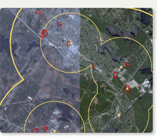
Manual site selection is costly, time consuming and risky. Not so with our Geographic Information System (GIS). Once you have provided us with your site selection parameters, our GIS can sort through thousands of potential sites to quickly and efficiently narrow them down to a select few sites. If required, our Valuation Division can provide guidance on the rental or market value of the selected properties. Our Brokerage Division can assist you rent or acquire the preferred property.

Scope of Work

We undertake Site Selection for all types of real estate:

  • ABMs
  • Airports
  • Apartments
  • Banks
  • Campgrounds
  • Coffee Shops
  • Container Piers
  • Farms
  • Fast Food Outlets
  • Fish Plants
  • Forestry Lands
  • Service Stations
  • Golf Courses
  • Gravel Pits
  • Harness Racing Track
  • Health Care Facilities
  • Hockey Arenas
  • Hotels
  • Housing Development
  • Industrial Property
  • Institutional
  • Mobile Home Parks
  • Motels
  • Movie Theatres
  • Nursing Homes
  • Offices
  • Orchards
  • Parks
  • Quarries
  • Recreational Lands
  • Radar Sites
  • Restaurants
  • Retail Outlets
  • Shopping Centres
  • Subdivisions
  • Swimming Pools
  • Taverns
  • Tennis Courts
  • Wineries

The Process

Having determined, through consultation with our client, the parameters that define their preferred site (locality; services; site size, zoning, topography, accessibility, visibility; proximity to markets, labour and competition; demographic and income data), we proceed through a sequence of research, analysis and recommendation.

Using our Geographic Information System (GIS) we demarcate the general study area on a map of Provincial parcel (PID) boundaries. We then narrow down the list of potential sites using a mixture of selection (site size), layering (services, zoning, elevation data, demographic and income data) and buffering (visibility; proximity to markets, labour and competition; psychographic data). Using a combination of local market knowledge and geo-referenced imagery (aerial and satellite photographs), we further refine the winnowing process by eliminating parcels which are unsuitable because, for example, they are sterilised for development or re-use by virtue of the type, age or size of their existing buildings. Once we have selected the potential sites, we conduct curb-side inspections to eliminate properties that do not meet the accessibility criteria. We then provide clear and unequivocal recommendations to our client on the sites that best meet their parameters for a preferred site. If required our Valuation Division can provide a value range, and most probable value, for each of the sites, to be included in our report.

Click here to review actual Site Selection case studies.

Contact Us